


Topographical factors are an objective natural influence and one of the main factors affecting the distribution of SRSCs in Nanjing and its surrounding areas. By overlaying the distribution map of SRSCs in Nanjing and its surrounding areas with the regional topographic elevation map, data show that these carvings are mainly concentrated in mountainous and hilly terrains such as the Zhongshan area, Mufu Mountain area, Qixia Mountain area, Yuhuatai area, and Danyang Hills. Most SRSCs are located at elevations between 9 and 40 m. By overlaying the SRSCs with the digital elevation model (DEM) for analysis33, elevation points for 63 SRSCs were obtained (Fig. 8).

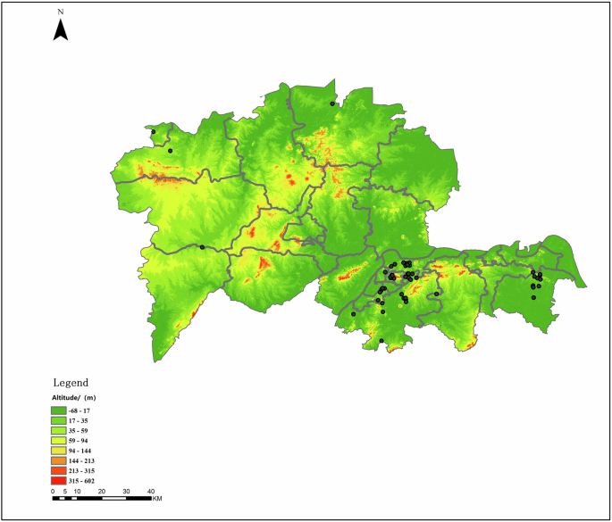
This figure presents a digital elevation model (DEM) of Nanjing and its surrounding regions, illustrating topographic variation and the altitudinal context of SRSCs. The background color gradient represents elevation in meters, ranging from dark green (lowest elevation, 0–17 m) to dark red (highest elevation, 213–602 m). The black diamond symbols indicate the locations of documented SRSCs. The map reveals that most of these carvings are distributed along low to moderate elevation zones (~35–144 m), primarily concentrated in the southern and southeastern parts of the study area. This spatial relationship suggests a preference for specific topographic conditions in burial site selection, aligning with traditional feng shui principles that favor locations at the foot of mountains and near water sources. The map includes administrative boundaries, a scale bar for distance reference, and a clearly defined legend indicating elevation ranges.
Among them, 29 SRSCs are located at an elevation of 9–20 m, accounting for 46% of the total; 25 are at an elevation of 21–40 m, accounting for 40%; eight are at an elevation of 40–60 m, accounting for 13%; and one is at an elevation of 61–70 m, accounting for 0.02% of the total.
By period, in the Southern Dynasties, 28 sites are located at an elevation of 9–20 m, accounting for 44.4% of the total; 11 are at an elevation of 21–40 m, accounting for 17.5%; and four are at an elevation of 40–60 m, accounting for 0.06% (Fig. 9a).

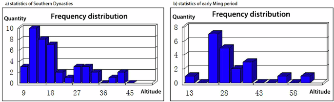
This figure presents two histograms comparing the elevation preferences of SRSCs from a the Southern Dynasties and b the early Ming period. The x-axis represents elevation (altitude in meters), while the y-axis indicates the quantity of SRSCs within each altitude range. Panel (a) shows that SRSCs from the Southern Dynasties are concentrated in low-altitude zones, particularly between 9–18 m, suggesting a strong preference for flat, river-adjacent terrain. In contrast, panel b reveals that SRSCs from the early Ming period shift slightly toward higher elevations, with most sites distributed between 13 and 43 m, indicating a broader altitudinal tolerance and potential changes in site selection criteria over time. These frequency distributions reflect evolving burial practices and highlight the influence of geographical and cultural factors in the spatial planning of spirit roads across different dynastic periods.
During the early Ming period, 1 spirit road stone carving is located at an elevation of 9–20 m, accounting for 0.02% of the total; 14 are at an elevation of 21–40 m, accounting for 22.2%; 4 are at an elevation of 40–60 m, accounting for 13%; and 1 is at an elevation of 61–70 m, accounting for 0.02% (Fig. 9b).
Nanjing and its surrounding areas are located in the Ningzhen-Yang Hills region, part of the Jiangnan hilly zone in southern China. Low mountains, hills, and undulating uplands account for ~60.8% of the city’s total area17. The widespread hilly terrain across Nanjing provided favorable natural conditions for the selection of elevated sites for tombs and their associated SRSCs.
Precipitation and the frequent occurrence of floods are also among the main climatic factors influencing the distribution of SRSCs in Nanjing and its surrounding areas. The middle and lower reaches of the Yangtze River, where Nanjing and its surrounding areas are located, belong to the subtropical monsoon climate zone, characterized by warm and humid conditions with distinct seasons. Historical and modern climatic records indicate that the annual precipitation in this region generally ranges from 800 to 1600 mm, while nearby hilly areas receive over 1600 mm per year. This persistent pattern of high precipitation has historically led to elevated groundwater levels and frequent seasonal flooding34.
Official historical chronicles in ancient China systematically recorded meteorological disasters. By examining official historical records from the Eastern Jin, Southern Dynasties, and Ming Dynasty, this study identified 76 flood events in Nanjing and its surrounding areas between 317 and 589 CE, and 31 flood events between 1368 and 1450 CE, totaling 109 flood events across these two periods, with an average occurrence of approximately once every 3 years (Table 3).
In ancient Chinese tomb construction, preventing water infiltration was always regarded as a primary consideration for site selection and structural design, as water penetration could lead to the decay of coffins, damage to burial objects, and collapse of burial chambers, causing severe destruction to the tombs. Based on the historical data, it is evident that frequent flooding in Nanjing and its vicinity would pose significant risks to tombs built at lower elevations. Therefore, given the widespread hilly terrain in this region, selecting higher-altitude hills and mountain slopes naturally became the preferred strategy for tomb placement.
Soil and lithological factors jointly influence the formation of the distribution of SRSCs in Nanjing and its surrounding areas. The soil types in Nanjing are mainly divided into two categories: zonal soils and cultivated soils. In the northern and central parts of Nanjing, zonal soils are predominantly yellow-brown soils, while in the southern areas bordering Anhui Province, red soils are more common. Cultivated soils, formed through long-term agricultural activities, are mainly paddy soils, along with some yellow paddy soils and vegetable garden soils17.
These soils share common characteristics, including fine texture, poor structure, heavy and compact consistency, and poor water retention and permeability, making them prone to waterlogging and soil erosion35. Based on the aforementioned climatic factors, it can be inferred that constructing tombs by deep excavation in low-elevation plain areas of Nanjing would inevitably lead to water seepage into burial chambers due to soil properties. Therefore, soil conditions further encouraged the selection of tomb sites on hilly terrains in Nanjing and its surrounding areas, to avoid structural damage caused by water infiltration.
The materials used for carving SRSCs are primarily limestone (CaCO₃), a type of sedimentary rock with a hardness of 2.7, which makes it easy to quarry. This type of stone typically occurs in block form, making it suitable for producing large-scale stone sculptures. Its fine crystalline structure provides resistance to weathering, facilitates precise detail carving, and ensures the clarity and durability of the carvings36. Limestone is widely distributed in mountainous areas around Nanjing, such as Zhong Mountain, Mufu Mountain, and Yang Mountain. The distribution of SRSCs within these mountain ranges facilitated convenient material sourcing, transportation, and on-site carving operations, effectively reducing production costs and providing strong support for the construction of these stone carvings.
In summary, the tomb site selection practices in the Nanjing region can be compared with those in dynasties that established their capitals in present-day Xi’an, such as the Qin and Han dynasties. Xi’an is located in the Guanzhong region, with the urban area situated on the second terrace of the Weihe Plain at an elevation of 400–700 m, characterized by deep soil deposits. The soils of the Weihe Plain are mainly yellow-brown and brown soils, featuring deep layers and compact texture37. Additionally, Xi’an has a continental monsoon climate with lower precipitation than Nanjing, resulting in minimal soil seepage risk.
Consequently, during the Qin and Han periods, imperial and noble tombs were often built in expansive areas and excavated deeply underground, with burial chambers connected to surface-level entrances via downward-sloping passages38. In contrast, for dynasties that established their capitals in Nanjing, the soil’s high permeability and the region’s frequent flooding events eliminated the feasibility of deep underground excavation for tomb construction39. However, the extensive hilly terrain in the area provided favorable natural conditions for constructing tombs on elevated sites (Table 4). As a result, tomb site selection in Nanjing adapted to local conditions by utilizing hilly landscapes, positioning tombs against hillsides and facing open plains. This led to the development of a distinctive system that evolved from the Qin and Han burial traditions, innovatively replacing underground tomb passages with above-ground spirit roads. According to historical records, the spirit road typically extends ~1000 m from the tomb entrance, following the natural terrain and topography. As a result, it is often not a straight line but rather curved, and the tomb and the spirit road are usually not aligned along a single central axis40. This indicates that imperial tombs in Nanjing and its surrounding areas were generally located on mountain foothills, slopes, or summits, while the spirit road extended from the foot of the mountain to the tomb entrance. The SRSCs, as above-ground architectural elements marking the beginning of the spirit road and symbolizing the tomb owner’s status and rank, were usually placed at a certain distance from the burial chamber on relatively flat terrain (Fig. 10).

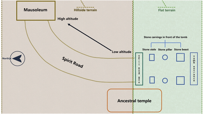
This diagram illustrates the typical spatial configuration of a traditional spirit road (shen dao) tomb complex, including the relationship between natural terrain, architectural elements, and stone carvings. The layout is divided into two topographic zones: the western section is hillside terrain with higher elevation, where the mausoleum is typically located; the eastern section is flat terrain at lower elevation, which houses the spirit road gate, ancestral temple, and ceremonial stone carvings. The spirit road curves upward from the spirit road gate toward the mausoleum, following a symbolic progression from low to high ground. Along the spirit road, a sequence of stone elements is positioned symmetrically in front of the tomb entrance, including stone steles (square), stone pillars (circular), and stone beasts (rectangular), which are integral components of traditional funerary architecture. The layout reflects geomantic (feng shui) principles, emphasizing elevation, cardinal orientation, and ritual symmetry. A north arrow provides directional reference, and all components are clearly labeled for interpretive clarity.
Consequently, the elevation of the SRSCs is lower than that of the tomb entrance, generally situated on relatively flat ground at elevations between 9 and 40 m, with a particular concentration between 9 and 20 m.
Hydrological factors play an indispensable role in the formation of the distribution of SRSCs in Nanjing and its surrounding areas. Using ArcGIS software, a multi-ring buffer analysis was conducted on level-5 and above water systems in Jiangsu and Anhui provinces, with buffer distances set at 5, 10, 15, and 20 km. The buffer area of rivers was calculated and overlaid with the distribution of SRSCs. Results show that 85.7% of SRSCs are located within 10 km of a river, and 93.7% of the total are within 15 km. As shown in Fig. 11, most SRSCs are distributed along river systems, mainly concentrated along the Nanjing section of the Yangtze River, the Qinhuai River, and the Danyang section of the Grand Canal. This pattern indicates that water sources, essential natural resources for human society’s production and livelihood, were a significant factor in selecting the locations for imperial tombs and SRSCs. In ancient times, proximity to water systems supported daily life and production needs, providing favorable conditions for the construction, maintenance, and visitation of SRSCs.

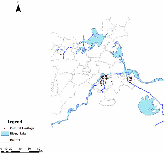
This map displays the distribution of cultural heritage sites (represented by red dots) in relation to the region’s hydrological features, including rivers and lakes (shown in blue), across multiple administrative districts (outlined in gray). The spatial clustering of cultural heritage sites near major water systems, particularly around the Yangtze River and its tributaries, is evident.
For example, the stone materials used in spirit road carvings or completed stone beasts, which are large and heavy, could be transported via waterways to their destination. According to a Chinese classic ancient book, “Book of Southern Qi Volume 22”, the stone beasts, stone pillars, and related materials for Emperor Wen’s Changning Tomb were transported from Xiangyang, Hubei, to Nanjing by Emperor Xiaowu41. Although the transport method is not specified, both Xiangyang and Nanjing are located along the Yangtze River, making water transport the most feasible method for moving such heavy materials. It can be inferred that the Yangtze River played a crucial role in the transportation involved in creating SRSCs. During the Southern Qi and Liang periods, imperial funeral processions and noble visits to tombs began by boarding ships at Fangshan in the southern suburbs of Nanjing, entering the Yangtze River, then traveling via canal to the Xiao Liang River, and finally heading north to the tombs in Danyang. This also highlights the importance of river systems as transportation routes for visiting and maintaining SRSCs.
Human factors have also jointly influenced the formation of the distribution of SRSCs in Nanjing and its surrounding areas, and can be divided into political and cultural factors. The political factors mainly include three aspects: (1)The capital city, as a political center, often exhibits a clustering effect of imperial tombs. As the capital of 11 dynasties, Nanjing served as the political and cultural center of the entire southern region for an extended period. Consequently, emperors and nobles who established their capitals in Nanjing selected tomb sites near the capital, facilitating the construction, management, and ritual offerings associated with the tombs and their SRSCs. The concentration of tombs near the capital also functioned as a means for the ruling class to display their power and authority to the populace. This phenomenon is common throughout Chinese history. Xi’an, Luoyang, Beijing, and Nanjing are collectively known as China’s “Four Great Ancient Capitals,” each having served as the capital for multiple dynasties. As a result, large numbers of imperial tombs are distributed around these cities (Table 5), with even more tombs belonging to princes, nobles, and high-ranking officials.
(2)The “Disaster of Yongjia,” a significant political upheaval that marked the end of the Jin dynasty, occurred in 311 CE. Following this event, invasions by northern nomadic groups into the Central Plains led to large-scale social unrest and mass population migrations. To escape the warfare, many people migrated southward across the Yangtze River. According to official historical records (Book of Jin, Book of Song), it is estimated that from 311 to 479 CE, approximately 900,000 people migrated southward, accounting for about one-sixth of the 5.4 million registered households in the Southern Dynasties and approximately one-eighth of the total northern population at that time.
The migration primarily involved aristocrats, scholars, and dependent commoners from the Central Plains, who often moved as family clans, forming so-called “qiaoxing” (migrating surname) groups. Prominent aristocratic families such as Wang, Xie, Yuan, and Xiao were representative of this southward migration. Among these, more than 220,000 migrants settled in Jingkou (present-day Zhenjiang, Jiangsu) and Jinling (present-day Changzhou, Jiangsu)42. The founder of the Liu-Song dynasty, Liu Yu, and the Xiao imperial family of the Southern Qi and Liang dynasties were notable representatives. Taking the Xiao family as an example, their ancestral home was in Lanling, Donghai (present-day Linyi, Shandong Province). Due to the turmoil, they migrated south with the Jin court, first settling in Jingkou (present-day Zhenjiang), and later moving to and permanently residing in Danyang (present-day Danyang, Zhenjiang)43. During the Southern Qi and Liang periods, the Xiao family rose to become the imperial household, gradually transforming from a northern migrant clan into a newly established southern aristocratic power (Fig. 12).

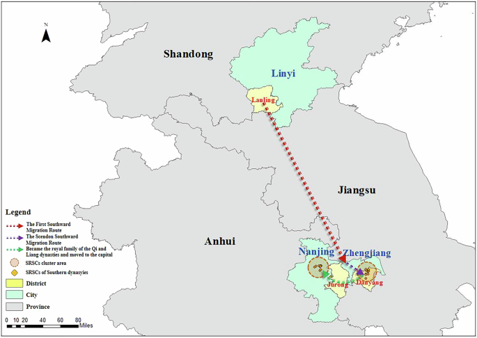
This map illustrates the historical migration routes of the Xiao family from the Lanling region in present-day Linyi, Shandong Province, to the southern capital area of Nanjing and Zhenjiang in Jiangsu Province. The dashed red arrow indicates the first major southward migration, while the dashed green arrow represents a secondary migration route. The orange circular symbols mark SRSCs cluster areas associated with the Southern Dynasties, particularly in Jurong and Danyang, where descendants of the Xiao family established tombs. These regions later became important burial grounds for members of the royal family during the Qi and Liang dynasties. Administrative divisions are outlined by different color shades: city-level units in yellow, provincial boundaries in green, and district borders in gray. The map emphasizes the correlation between historical family migration patterns and the spatial distribution of their monumental funerary SRSCs, shedding light on the political and cultural shifts of the period. A scale bar is provided for distance reference.
The imperial tombs of the Xiao family were distributed in two main areas: one group of 14 tombs was constructed near Jiankang (present-day Nanjing) due to the political centrality of the capital, while another group of 14 tombs (including one in Jurong) was built in Danyang, their settlement after migration. This made Danyang, besides Nanjing, another major area with a concentrated distribution of SRSCs (Table 6).
(3) Alternative capital city. Fengyang was the hometown of Zhu Yuanzhang, the founding emperor of the Ming Dynasty. The Ming Imperial Mausoleum, the joint burial site of Zhu Yuanzhang’s parents, is located in Fengyang, Anhui Province (present-day Fengyang County, Chuzhou City, Anhui Province). In the second year of the Hongwu reign (1369), Fengyang was designated by Zhu Yuanzhang as “Zhongdu” (the Central Capital), and at one point it was considered a potential alternative capital for the Ming Dynasty44. During the three construction phases of the Ming Imperial Mausoleum from 1366 to 1379, its location remained in Fengyang without relocation. One important reason for this was that, as a designated alternative capital, Fengyang needed prominent royal infrastructure projects to assert its political status. This also illustrates how political factors influenced the siting of SRSCs45.
In addition to political factors, cultural factors also jointly influenced the distribution of tombs and their SRSCs. The cultural factors include three aspects: traditional funerary beliefs, the continuity of burial systems, and the influence of feng shui culture. In traditional Chinese culture, there is a strong emphasis on the concept of being buried in one’s hometown after death and the burial practice of family members being interred together in family clusters. Taking the Xiao family as an example, after the “Disaster of Yongjia,” they migrated south to Danyang for political asylum and eventually settled and flourished there. After death, family members could no longer return to their original hometown of Lanling, Donghai (present-day Lanling County, Linyi City, Shandong Province) for burial. Instead, they were buried in Danyang, their “second hometown” after migration, following the family practice of “burial by clan”46. This was an important factor, aside from political considerations, contributing to Danyang becoming a major cluster area for SRSCs in the Jiangnan region. Many similar examples existed in the early Ming period as well. Fengyang, the site of the Ming Imperial Mausoleum, was the hometown of Emperor Zhu Yuanzhang and the burial place of his parents. The Ming Zuling Mausoleum, located at Yangjiadun north of Sizhou City (present-day Xuyi County, Jiangsu Province), was the residence and burial place of Zhu Yuanzhang’s grandfather, Zhu Chuyi. Among the founding ministers of the Ming Dynasty, Tang He’s tomb was located in his hometown, Donghu Village, Fengyang (present-day Longzihu District, Bengbu City, Anhui Province), while Wu Fu’s tomb was located in his hometown, Liang County (present-day Xiaoxu Township, Feidong County, Anhui Province). Most of the hometowns of Emperor Zhu Yuanzhang and his founding ministers were in present-day Anhui Province. This explains why SRSCs are scattered across Anhui as well.
According to official historical records, starting from Liu Jiao, King Yuan of Chu in the Western Han Dynasty, there was already a practice of constructing tombs by carving into mountains47. This burial system was subsequently adopted by Emperor Wen of Han and later further developed by Emperor Wen of Wei, Cao Pi, who advocated the burial method of “using mountains as tombs”48. After the “Disaster of Yongjia,” the Jin imperial family migrated eastward, and northern people moved south. When these northern migrants and their descendants became rulers in the Jiangnan region (such as the emperors of the Eastern Jin and Southern Dynasties), they brought with them the concept and burial system of “using mountains as tombs.” Meanwhile, in ancient Jiangnan, particularly in the Wu and Yue regions, various forms of primitive worship were prevalent, among which mountain and river worship was especially prominent. Archeological findings from the Liangzhu culture, which represents ancient Wu and Yue culture, reveal numerous elevated altars built on high platforms, used as burial sites. The underlying reason was that ancient people hoped that by building altars on higher grounds, they could shorten the distance between humans and heaven, facilitating communication with the heavens49. Burying tombs at such locations symbolized the deceased’s aspiration for their soul to ascend quickly to heaven, thereby reinforcing their earthly power and status. The integration of the mountain and river worship beliefs of indigenous Jiangnan culture with the northern migrants’ burial ideology of “using mountains as tombs” became a significant basis for selecting mountain areas as burial sites for Southern Dynasties aristocrats. This cultural synthesis explains why SRSCs in Nanjing and its surrounding areas are distributed along mountain foothills such as Zhong Mountain, Mufu Mountain, and Jubao Mountain. Chinese feng shui culture has a long and profound history. It originated during the Xia dynasty approximately four to five thousand years ago, developed during the Shang and Zhou periods, took shape during the Qin and Han dynasties, and reached a more mature form during the Wei and Jin periods, eventually flourishing in the Ming and Qing dynasties. Specialized works on feng shui include Qing Nang Jing (The Classic of the Green Satchel), Zang Shu (The Book of Burial), and Yangzhai Sanyao (Three Essentials of the Living House)50. Although most official historical records do not explicitly state that emperors and aristocrats selected tomb sites in mountainous areas due to feng shui considerations, there are exceptions. For example, Records of the Grand Historian (Shiji, “Biography of Chuli Zi”) and Records of the Three Kingdoms (Sanguozhi, “Biography of Guan Lu”) explicitly mention events where feng shui influenced tomb site selection. The publication of specialized feng shui texts and these historical accounts are sufficient to demonstrate the significant impact of feng shui on ancient Chinese society. Feng shui theory posits that the feng shui of ancestors’ tombs can influence the fortune of their descendants, while the feng shui of emperors’ tombs can impact the fate of the entire state. Regarding site selection, feng shui emphasizes the principle of “relying on mountains and facing water,” meaning that tombs should be built backed by high mountains, facing water, and enclosed by lower hills on both sides, ideally in a semi-enclosed area on the mountainside or in a mountain valley51. A typical example is the Book of Burial authored by Guo Pu during the Eastern Jin period, which is considered the foundational text of feng shui culture. It systematically elaborates on feng shui theory and was the first to formally introduce the term “feng shui.” The text clearly states that tombs should have high mountains at the back, protective hills on both sides, and an open area in front to block strong winds and create an environment conducive to accumulating and preserving “qi”52. Nanjing, historically known as Jinling, is characterized by mountainous and hilly terrain, offering numerous sites that meet the “relying on mountains and facing water” requirements of feng shui for tombs. Additionally, during the early Ming period, Emperor Zhu Yuanzhang once considered relocating the Ming Imperial Mausoleum from Fengyang to Nanjing. However, officials advised that relocating the mausoleum might cause the loss of spiritual energy accumulated in the original mountain and river setting, potentially affecting the fate of the dynasty(“时有言改葬恐泄山川灵气者, 乃不复改”)53. Zhu Yuanzhang accepted this suggestion, and the mausoleum ultimately remained in Fengyang. This is another example demonstrating how feng shui theory influenced the site selection of SRSCs. Based on these feng shui texts, historical records, and the objective topographical conditions of Nanjing’s hilly landscape, it is reasonable to infer that the distribution of tombs and their SRSCs in hilly areas during the Southern Dynasties and the early Ming period was influenced by feng shui culture.
This study systematically analyzed the spatial distribution and spatiotemporal evolution characteristics of SRSCs in Nanjing and its surrounding areas by employing Geographic Information Systems (GIS) and historical-geographical methods, extracting historical data from official historical records. It identified natural factors as objective influences and cultural factors as subjective influences, jointly shaping the spatiotemporal distribution and evolution of SRSCs. The key findings include: (1) SRSCs exhibit significant clustered distribution, forming a spatial structure centered primarily around Qixia and Xuanwu districts of Nanjing, with Danyang as a secondary center. Other areas exhibit scattered distributions, showing an overall density gradient evolving from the west and northwest towards the southeast. (2) The distribution of SRSCs is spatially uneven. During the Southern Dynasties period, carvings were predominantly concentrated in Qixia District, Jiangning District in Nanjing, and Danyang City in Zhenjiang, collectively accounting for 63.5% of the total. During the early Ming Dynasty, the main distribution shifted northwestward by 52.27 km, focusing primarily in the Xuanwu and Yuhuatai districts of Nanjing. (3) Natural factors are predominant objective determinants for the distribution of SRSCs, resulting in most carvings being situated at elevations below 40 meters. Above this elevation, the quantity of carvings decreases with increasing altitude. Additionally, 85.7% of SRSCs are located within 10 km of rivers. (4) Political and cultural factors significantly influenced the distribution patterns of SRSCs. These factors do not act independently but rather intertwine and interact with natural conditions to shape the spatial arrangements of SRSCs. The innovations of this study are highlighted in three aspects. Firstly, SRSCs represent a crucial yet relatively understudied component of the Chinese burial system, with previous research largely confined to archeological and art historical fields, leaving geographical analyses of their spatial characteristics and formation mechanisms largely unexplored. Secondly, this study innovatively integrates GIS-based spatial analysis with historical text mining, overcoming the disciplinary limitations of traditional SRSCs studies, thereby elucidating the spatial patterns and evolution rules driven by combined natural and cultural factors. Lastly, based on the methodology and findings of this research, the author further developed preliminary 3D digital modeling and virtual reality presentations of SRSCs, achieving digital innovations in heritage conservation and dissemination, and demonstrating the research’s value and potential (Fig. 13). Moreover, integrating GIS analysis with various natural disaster risk datasets can provide technical support for disaster risk assessment, early warning systems, and emergency responses for SRSCs. Multidimensional digital technologies centered around GIS offer novel perspectives and methodologies for the protection and preservation of immovable cultural relics exemplified by SRSCs.

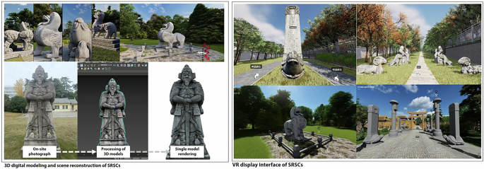
This figure presents the final results of the 3D digital modeling and virtual reality display of SRSCs. The top left shows the 3D modeling render of Southern Dynasty SRSCs. The bottom left displays the 3D digital modeling process of early Ming Dynasty SRSCs. The top right is a screenshot of the virtual panoramic tour interface for the early Ming SRSCs, while the bottom right is a screenshot of the virtual panoramic tour interface for the Southern Dynasty SRSCs.
link