


Suitability-ecology-benefit synergy in reconstructing settlements
The findings of this study reveal that 46.7% of Xiaoliangshan’s territory is classified as low or non-adaptable due to steep terrain, high elevation, or ecological fragility. These areas generally exhibit slopes greater than 25°, while only 4.3% of the basin areas are considered highly adaptable. This outcome aligns with the core premise of research on settlement Suitability in mountainous regions, namely that slope is a fundamental constraint on settlement distribution49. For instance, areas with steeper slopes display a marked decline in settlement density, a pattern corroborated by studies in the Taihu Basin of Huzhou, Zhejiang Province50, and in southeastern Guizhou Province51. However, the study further uncovers the rigid threshold effect imposed by ecological protection policies. Although the non-adaptable area surrounding Lugu Lake accounts for only 0.84% of the total land area, ecological protection regulations—such as strict prohibitions on development—have led to a complete exclusion of modeled settlements in this zone. This result validates the mandatory enforcement power of China’s ecological redline policy in spatial planning52. Similar mechanisms have been documented globally. For example, in the Amazon rainforest, deforestation in the Brazilian Amazon was reduced by 70% from its 2005 peak to 5,843 km² in 2013, primarily due to legal restrictions and supply chain interventions, offering a model for global sustainable development53. Likewise, in the Indian Himalayas, approximately 5% of India’s national territory has been designated as protected areas, including 104 national parks and 551 wildlife sanctuaries. These areas are legally supported by the Indian Constitution and the Wildlife Protection Act, with judicial enforcement by the Supreme Court further strengthening conservation efforts54. Such cases underscore the universal relevance of ecological protection policies in fragile areas.
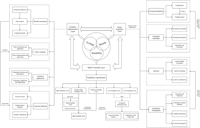
Nevertheless, while ecological constraints effectively reduce environmental risks, they may also exacerbate development challenges for marginal communities. The optimization results, as reported in Fig. 6, indicate that in the western hot-dry river valleys, particularly around Labo Township near the main stem of the Jinsha River, the model generated a prominent “island-like” highly suitable zone for settlement development, accompanied by several scattered moderately high suitability zones. Indigenous communities in these areas traditionally rely on pastoralism and sloped farming; forced relocation may disrupt their livelihoods. Comparable tensions are reported in other ecologically sensitive regions globally. For example, in Kenya’s Maasai areas, government land reform policies led to the loss of half of the rangelands to non-Maasai groups, weakening traditional nomadic livelihoods and intensifying land resource inequality. These changes have posed a serious threat to both the Maasai way of life and the local ecosystem’s sustainability55. In Rajasthan, India, the Raika camel pastoralists have been forced to alter their migratory routes and grazing practices due to a dramatic decline in rangeland since the mid-20th century. This shift has transitioned their livelihoods from fully nomadic to semi-nomadic or sedentary forms, impacting their cultural heritage and placing pressure on local ecosystems through overgrazing and land degradation. While ecological constraints may help protect remaining rangelands, they also intensify livelihood vulnerabilities and dependency on alternative income sources56. Similarly, in Iran, the combined effects of industrial and mining expansion and climate change have significantly reduced nomadic populations, weakening traditional pastoral livelihoods and accelerating unsustainable land-use transitions, thereby worsening ecological degradation57.
To mitigate the conflict between ecological conservation and community development, it is essential to explore innovative applications of ecological compensation mechanisms. Several case studies from China have attempted to balance these competing priorities. For example, in the Chishui River Basin, the government and private enterprises jointly established a water fund platform. By incentivizing ecological conservation, fostering ecological industries, and improving institutional frameworks, this initiative has promoted a virtuous cycle between watershed protection and regional economic development58. In the ecological redline zones of Shandong Province, diversified compensation strategies—such as vocational training, support for eco-agriculture, and the development of green industries—have optimized the employment structure, stimulated developmental consumption, and strengthened households’ endogenous motivation for wealth creation, thereby significantly improving subjective well-being and resilience among rural families59. Additionally, in these zones, capacity-building compensation mechanisms have provided intellectual services and industrial support to help rural households develop sustainable livelihoods, gradually reducing their dependence on direct government transfers60.
These examples demonstrate that innovative ecological compensation mechanisms can effectively alleviate tensions between ecological conservation and community development. Such mechanisms not only reduce the ecological impact of settlement expansion but also revitalize community-driven development, enabling a virtuous cycle of “development through protection.” Building upon both the findings of this study and previous research, we propose a synergistic “Suitability–Ecology–Benefit” mechanism for the spatial reconstruction of settlements in ecologically fragile areas. This mechanism comprises three tiers: rigid constraints, flexible adjustment, and dynamic optimization. At the foundation, the mechanism relies on spatial Suitability assessments to classify spatial units into zones of varying Suitability. Zoning strategies—such as relocation and reorganization, in-situ development, and ecological conservation—are then devised based on each zone’s ecological value and development potential. settlements located in low- and non-adaptive zones are eliminated accordingly. At the flexible adjustment level, mechanisms such as ecological banks and tradable ecological quotas are introduced. Medium-Suitability zones near conservation areas act as suppliers, while medium-high and high-Suitability zones serve as demand areas. Through the monetization of ecological services such as carbon sequestration, water resources, and tourism revenues, spatial and market-based optimization of resource allocation is achieved. Moreover, a portion of the government’s targeted poverty-alleviation and conservation funds is allocated as wages to hire elderly and middle-aged residents in medium-Suitability zones for ecological patrols and environmental maintenance.
To quantify the implicit value of ecological resources and guide the market-based pricing of ecological quotas, a shadow pricing model is introduced. Under conditions of optimal resource use, the contribution of a unit resource to the objective is defined as its shadow price. This value reflects both the resource’s scarcity and marginal contribution, thereby representing its true economic value61,62,63. When the actual market price is lower than the shadow price, the resource should be purchased; when it is higher, the resource should be sold. Unlike traditional market prices, shadow prices are not actual transaction values but virtual prices that reflect the real social cost of resources.
In the Xiaoliangshan, we recommend constructing a dynamic shadow pricing model based on four ecological quota types: carbon sequestration units (CUs), water use units (WUs), tourism-linked revenue credits (TLRCs), and biodiversity units (BUs). This model enables the quantification, marketization, and sustainable management of ecological resource values. Based on the dynamic pricing of these four quotas, the preliminary model formula is as follows:
$$\:{P}_{total}\left(t\right)=\sum\:_{i=1}^{4}\:\left[{\omega\:}_{i}\left(t\right)\cdot\:{P}_{i}\left(t\right)\cdot\:{F}_{i}\left(t\right)\right]+\epsilon\left(t\right)$$
Where,\(\:{\omega\:}_{i}\left(t\right)\)is the weight coefficient of each quota, \(\:{P}_{i}\left(t\right)\)is the base price, \(\:{F}_{i}\left(t\right)\)is the dynamic adjustment factor (reflecting ecological, social, and economic feedback), and \(\:\epsilon\left(t\right)\)is the random disturbance term (e.g., due to climate variability or policy shocks). Based on the shadow pricing model, four categories of quotas are preliminarily defined, with relevant information provided in Table 7. Finally, at the dynamic optimization level, the mechanism is supported by technological infrastructure, policy guidance, and an evaluation feedback system to ensure its sustainable operation and periodic adjustment of objectives—ultimately achieving the coordinated integration of ecological protection, community development, and economic benefits (Fig. 8).
However, in the optimization of settlements in mountainous areas, balancing Suitability and spatial efficiency presents a persistent challenge. Findings from this study using an ant colony optimization algorithm indicate that increasing the weight of Suitability significantly improves the alignment of settlements with flat terrain. However, this comes at the cost of reduced compactness, potentially increasing infrastructure expenditures. This finding highlights the inherent contradiction between Suitability and spatial efficiency in the optimization of mountainous settlements. In general, improving land use efficiency is typically associated with more compact layouts and more efficient resource use—common goals in both urban planning and rural settlement optimization. Nevertheless, such compact designs can alter existing community structures and weaken social ties. For example, Kong et al. employed a Particle Swarm Optimization (PSO)algorithm to optimize rural settlement patterns and found that social connectivity directly influences the direction of settlement reconstruction. In some cases, spatial compactness may need to be compromised. A highly compact layout can reduce interactions among farmers, thereby weakening their social networks and sense of belonging36. Similarly, Li et al. observed in their study on rural land consolidation in China that improvements in land use efficiency often come at the expense of social cohesion64. This is largely because compact layouts may decrease opportunities for interpersonal interaction, ultimately undermining local community networks. Therefore, it is recommended to incorporate multi-objective parameters into optimization algorithms rather than relying solely on single-weight adjustments.
To achieve sustainable development of settlements in ecologically fragile areas, a three-pronged approach is proposed. First, development in ecological conservation zones and low-Suitability areas (such as the dry-hot valley of the Jinsha River and the Lugu Lake Ecological Protection Zone) should be strictly restricted through tiered regulation and control. Priority should be given to guiding settlements toward medium-high and high Suitability zones. Second, ecological compensation innovations should be explored through the “ecological bank” model65, whereby developers in higher Suitability zones are allowed to purchase ecological quotas (e.g., carbon sequestration credits, water conservation capacity) from lower Suitability zones. This approach transforms the cost of ecological protection into market-based returns. Third, optimization algorithms should be integrated with participatory planning processes that incorporate community cultural preferences—such as traditional layouts and the preservation of religious sites—to avoid disjunctions between “technocratic rationality” and “social needs.” This mechanism is grounded in graded Suitability assessments and rigid ecological constraints, and promotes a dynamic balance between conservation and development. It navigates the complex trade-offs between spatial efficiency and economic cost. In doing so, it offers a viable pathway for optimizing settlement distribution in Xiaoliangshan—encouraging concentration toward flatter areas while retreating from ecologically sensitive zones. The approach also serves as a reference model for settlement planning in similar regions globally, ultimately contributing to both regional ecological security and community well-being (Fig. 8).

Suitability – Ecology – Benefit mechanism in the Reconstruction of Settlements.
The sustainable development path of settlement landscapes
In this study, the settlement landscape demonstrates a spatially differentiated pattern between urban and rural areas (e.g., urban CLUMPY = 0.576 vs. rural ED = 9.92 m/hm²), which can largely be attributed to the coupled effects of natural geographic constraints and policy interventions. Topography plays a dominant role in shaping the dispersed nature of rural settlements. For instance, the fragmented distribution in the western dry-hot valleys (with slopes > 15°, PD = 124.33 patches/km²) is directly constrained by the scarcity of arable land resources—a pattern consistent with settlement distributions in other mountainous agricultural systems66,67. In contrast, areas with higher urbanization rates exhibit greater aggregation of settlements (e.g., Hongqiao Town, AI = 99.93), closely linked to land consolidation policies such as the “linking increase with decrease” approach. These policies encourage urban development to concentrate in flat basin areas by reclaiming and reallocating rural construction land quotas. The polarizing effect of infrastructure further intensifies this differentiation—for example, the density of settlements along major transportation corridors (> 50 settlements/km²) is significantly higher than in remote mountainous areas, reinforcing the core principles of Transit-Oriented Development (TOD)theory68.
However, such spatial differentiation carries substantial sustainability risks. Urban expansion may encroach upon ecologically sensitive areas—for example, in Daxing Town, the largest patch index (LPI = 97.32%) approaches wetland buffer zones, exacerbating the risk of water pollution. On the other hand, fragmentation in rural areas (ED = 9.92 m/hm²) compromises disaster resilience. For instance, in Zichala Village of Zhanhe Town, during a sudden storm from the evening of September 12 to the early morning of September 13, 2020, a 24-hour rainfall of 180.3 mm triggered flash floods that destroyed roads, farmland, and settlements. Similarly, in Cuiyu Township, from July 20 to July 21, 2024, continuous heavy rainfall led to flash floods, mudslides, and landslides, necessitating the emergency evacuation of 15 households totaling 63 individuals.
Moreover, ecological relocation policies and the decline of traditional shifting cultivation systems (e.g., abandoned terraced fields and pastures) have disrupted the human–land relationship, accelerating the erosion of indigenous cultural heritage. In response, building on the previously discussed “Suitability–Ecology–Benefit” synergistic mechanism, this study further refines a spatial reconstruction strategy for settlements. At its core, this strategy offers a systematic solution to reconcile ecological conservation, cultural heritage preservation, and development demands through geographically-informed spatial planning of urban and rural settlements.
The specific practical details of this approach are elaborated in the following three aspects:
First, the spatial organization logic should break through the traditional paradigms of mountainous planning. Basin areas such as Yongning, Ninglang, Hongqi, Hongqiao, and Cuiyu are designated as key regions for future urbanization. These areas should be developed to enhance their overall carrying capacity and service level, improve the ecological and cultural environments of towns, protect and transmit urban cultural heritage, and coordinate the distribution of public service facilities. Simultaneously, ecological corridors should be constructed along basin edges to restore wetland ecosystems. By positioning basin regions as the core carriers of urbanization, this approach effectively addresses the “dispersed trap” often found in highland gorge areas. Enhancing the comprehensive capacity of basins avoids the ecological sensitivities associated with valleys, while also inheriting the traditional spatial logic of Southwest China’s ethnic regions—“basin as core, mountain as shield”69. The construction of ecological corridors along basin margins reflects the integration of the patch–corridor–matrix theory in landscape ecology with local cultural landscape preservation, thus balancing urban expansion with the integrity of cultural landscapes70.
Second, a graded ecological governance mechanism should be established. An ecological protection zone should be constructed along the Jinsha River valley in the western parts of Labo, Cuiyu, Jinmian, and Xichuan townships, where scattered settlements would be relocated and reorganized into clustered settlement groups in nearby small basins. Shared infrastructure would reduce service costs. The delineation of the Jinsha River valley protection belt and the reconfiguration of settlement clusters embody the zoning governance concept of “core protected area – buffer transition zone.” By concentrating scattered settlements into compact basin clusters, infrastructure provision becomes more cost-efficient, and more critically, the spatial scale of the human–land relationship is restructured. This enables a controlled retreat of human activity from ecologically sensitive areas, while preserving the traditional social structure of -based communities. Compared to forced relocation policies, this “flexible relocation” model better aligns with the community-based conservation principles advocated by the Convention on Biological Diversity71.
Third, a bidirectional connectivity framework should be established for regional development. settlement clusters should be strategically positioned along the north–south and east–west transportation development corridors in Xiaoliangshan. The north–south urban development axis would connect externally with Sichuan to the north and central Yunnan to the south, while internally linking township nodes from south to north: Zhanhe Town, Paomaping Township, Xinyingpan Township, Daxing Town, Hongqiao Town, and Yongning Town for coordinated development. The east–west axis, leveraging the Lijiang–Ninglang and Xichang–Shangri-La expressways, would integrate Xiaoliangshan with Lijiang and Xichang. These north–south and east–west corridors aim to activate multi-level flows by improving spatial accessibility: at the county scale, linking township nodes into a synergistic development framework; at the regional scale, interfacing with the major economic zones of Sichuan and Yunnan; and at the cultural scale, embedding into the Greater Shangri-La tourism corridor. This multi-tiered network construction both inherits the core principles of the “point–axis system” theory and innovatively incorporates ethnic cultural routes into spatial planning systems72, offering a culturally embedded paradigm for mountain transportation-economic belt development. Future research could further explore basin carrying capacities and differentiated responses among ethnic groups to the spatial reconstruction of settlements.
Enhanced applicability of algorithms in Indigenous settlement optimization
This study achieved significant optimization of settlement spatial layouts through the application of the ant colony algorithm, with its core contribution lying in the validation of the scientific value of technological tools for terrain adaptation and ecological avoidance. However, the potential of algorithmic optimization extends beyond improving spatial efficiency; it should also be leveraged as a mediating tool for integrating cultural heritage and ecological Suitability. The results show that the post-optimization concentration of settlements in basin areas significantly enhanced land use efficiency. However, this process can be further enriched by deeply integrating traditional adaptive knowledge. For instance, the indigenous layout of Xiaoliangshan—developed by “adapting to mountain terrain”—is essentially a spatial adaptation strategy rooted in long-term experiential knowledge. In future local-scale optimization scenarios, algorithmic models can localize parameters to encode such traditional knowledge as constraint conditions. For example, incorporating a “traditional layout compatibility” indicator into the objective function could quantify the cultural significance of orientation and the placement of public spaces (e.g., hearths, prayer halls, sacrificial plazas). Similarly, traditional understandings of disaster avoidance (e.g., avoidance of sacred mountain areas) can be integrated with modern landslide monitoring data to refine avoidance thresholds. Such integration not only preserves the algorithm’s efficiency but also prevents the cultural erosion risk associated with “technological replacement of tradition,” aligning with UNESCO’s initiative on “indigenous knowledge for sustainable development”73.
Moreover, the true value of algorithms lies in their openness. Through participatory algorithm design, spatial demands from community members—such as ancestral house preservation or the continuity of livestock trails—can be translated into model parameters, enabling “technological empowerment” rather than “technological domination.” The spatial restructuring of settlements post-optimization not only improves functional efficiency but also provides a material foundation for cultural practices. For example, centralized layouts allow for more efficient allocation of public cultural facilities (such as sacrificial plazas or intangible cultural heritage workshops), while traditional livelihood patterns (e.g., terraced farming, festival rituals) are reinforced through spatial clustering, enhancing community cohesion.
Therefore, intelligent algorithms should not be seen as antithetical to cultural heritage, but rather as potential carriers of its innovation. Future research should further explore interdisciplinary methodologies to more precisely capture the spatial expression of cultural variables, thereby providing scientifically grounded yet culturally sensitive solutions for the sustainable development of mountain communities worldwide.
Incorporating local voices and Indigenous worldviews into the optimization framework
The integration of local perspectives and Indigenous worldviews is essential for ensuring that settlement optimization in ecologically fragile mountainous areas is both technically sound and socially legitimate. In this study, the Spatial Suitability Evaluation Index System (Table 2) was designed not only on the basis of spatial data analysis but also through qualitative inputs gathered from field visits and informal community discussions.
During interviews, residents consistently emphasized the importance of proximity to township centers and central villages for maintaining daily social interaction, accessing public services, and ensuring educational opportunities for their children. One villager expressed, “We hope not to be too far from the township, so that our children can go to school conveniently.” This sentiment is directly reflected in the model through the high weights assigned to distance from township centers (0.3148) and distance from central villages (0.1510). These weights represent more than quantitative parameters—they embed the community’s priorities for accessibility, cohesion, and intergenerational opportunity. Similarly, local perspectives influenced the treatment of land use and ecological constraints. For example, the preference for retaining cultivated land for subsistence farming aligns with the assignment of higher suitability scores to agricultural land types. The avoidance of nature reserves and geologically hazardous areas reflects both formal conservation policies and culturally recognized ecological boundaries, some of which hold spiritual significance for local communities.
By embedding these priorities into the optimization framework, the Suitability–Ecology–Benefit mechanism moves beyond a purely technical model to one that resonates with Indigenous values and lived realities. While the computational process identifies optimal configurations under ecological and socio-economic criteria, its implementation is envisioned as a participatory and co-managed process—consistent with the United Nations Declaration on the Rights of Indigenous Peoples (UNDRIP) and UNESCO’s principles for safeguarding cultural heritage. This approach ensures that optimized settlement layouts are not only ecologically resilient but also culturally appropriate and socially acceptable.
Theoretical integration and limitations
The optimization of Indigenous settlements in ecologically fragile mountainous areas is best understood through a combined framing of the Territorial System of Human–Environment Interaction (TSHEI) and Sustainable Development Theory, enriched by international perspectives on Indigenous rights and participatory governance. TSHEI provides a systems lens that highlights thresholds, feedbacks and the coupled dynamics of social and biophysical subsystems; Sustainable Development Theory supplies a multi-objective normative frame that balances ecological protection, social equity and economic viability. Together they justify an analytical workflow that identifies ecological constraints, assesses multi-dimensional suitability, and tests spatial reorganization scenarios.
To enhance both the legitimacy and practicability of settlement optimization, this study situates its findings within broader debates on Indigenous agency, co-management, and participatory planning. International frameworks such as the United Nations Declaration on the Rights of Indigenous Peoples (UNDRIP) emphasize Indigenous peoples’ rights to participate in decisions affecting lands and resources, and to maintain cultural heritage and governance systems74. UNESCO’s conventions and recommendations on safeguarding cultural and intangible heritage similarly call for recognition of community knowledge and inclusive safeguarding measures in spatial and cultural planning75.
Scholarly work on co-management and adaptive governance underscores that durable conservation and development outcomes are most likely when local knowledge, institutions and state actors interact in negotiated arrangements rather than through purely top-down directives76. Participatory planning and stakeholder engagement studies further show that including local stakeholders improves decision quality and social legitimacy, while also surfacing trade-offs and conflict loci that technical models alone cannot reveal77. Empirically, our Suitability–Ecology–Benefit mechanism can be read as a spatial-technical scaffold that is strengthened by these participatory and rights-based approaches: algorithmic optimization identifies candidate locations that respect ecological thresholds, while participatory procedures and co-management institutions would be required to translate optimized configurations into legitimate, culturally appropriate, and durable outcomes on the ground. In other words, the computational outputs provide evidence-based options, but implementing them in a way that respects Indigenous rights and local livelihoods requires procedural protections (consultation, free, prior and informed consent where relevant), co-management arrangements, and benefit-sharing mechanisms — consistent with UNDRIP and related best practice78.
This study explicitly prioritized ecological fragility in the optimization framework, focusing analytical effort on tangible ecological constraints and landscape indicators. Nevertheless, several limitations should be acknowledged. First, due to the region’s unique development context and partial data limitations, not all dimensions of China’s Three-Zone and Three-Line policies—particularly permanent basic farmland protection and urban development boundaries—were fully incorporated into the model. These omissions, while reflecting the availability and resolution of spatial data, may have constrained the comprehensiveness of the optimization. Second, the applicability of the findings beyond Xiaoliangshan should be approached with caution; the framework is most likely to be transferable to other mountainous indigenous regions with comparable data availability, governance settings, and terrain-ecology profiles, rather than to rural regions more broadly. For instance, the model’s reliance on specific ecological and topographic datasets limits its direct applicability to regions with differing data structures or environmental conditions.Third, cultural dimensions—such as kinship-based land tenure, customary settlement clustering, and ceremonial spatial arrangements—were only indirectly reflected in the current optimization process; future research should explore formal methods for integrating such factors into algorithmic models to enhance cultural alignment. Finally, the modular structure of the framework enables adaptation to evolving ecological, economic, or social conditions by updating environmental datasets, recalibrating socio-economic parameters, and modifying constraint hierarchies. This adaptability is particularly relevant under climate change scenarios or in response to rapid policy adjustments, where scenario-based simulations could be employed to anticipate and optimize settlement configurations under shifting conditions. Despite these limitations, the study provides a robust and context-specific basis for guiding model-based settlement optimization in ecologically sensitive mountain regions.
link